Discover the most spectacular trails in
Cerro Castillo National Park
The Las Horquetas Trail System is 53.5 kms of pure beauty through Patagonian wilderness. With 5 different camping zones and rustic trails passing through native forests, you’ll be immersed in nature with chances to see condors, huemules, pumas and much more.

DOWNLOAD THE MAP IN .KMZ FORMAT
HIKING TRAILS
Cerro Castillo National Park
Our trails are all well marked by yellow markers installed in accordance with Conaf. Critical areas in the route are marked to alert you of dangerous areas and bridges are installed over turbulent rivers. Please keep in mind all trajectory times are approximations and depend on your personal hiking ability and physical condition.
ATTENTION:
- The old Campamento Bosque is in recovery of vegetation and is located 40 minutes further inland when you come from Las Horquetas (or East to West). Please follow the signs on the trail to get to the new camp.
- Camp La Tetera is closed for recovery.

TRAMO 1: CASETA LAS HORQUETAS - CAMPAMENTO TURBIO
15.4 kms. | DIFICULTY: LOW
Duration: 5-6 hours approx.
Ascent: 440 meters.
Descent: 250 meters.
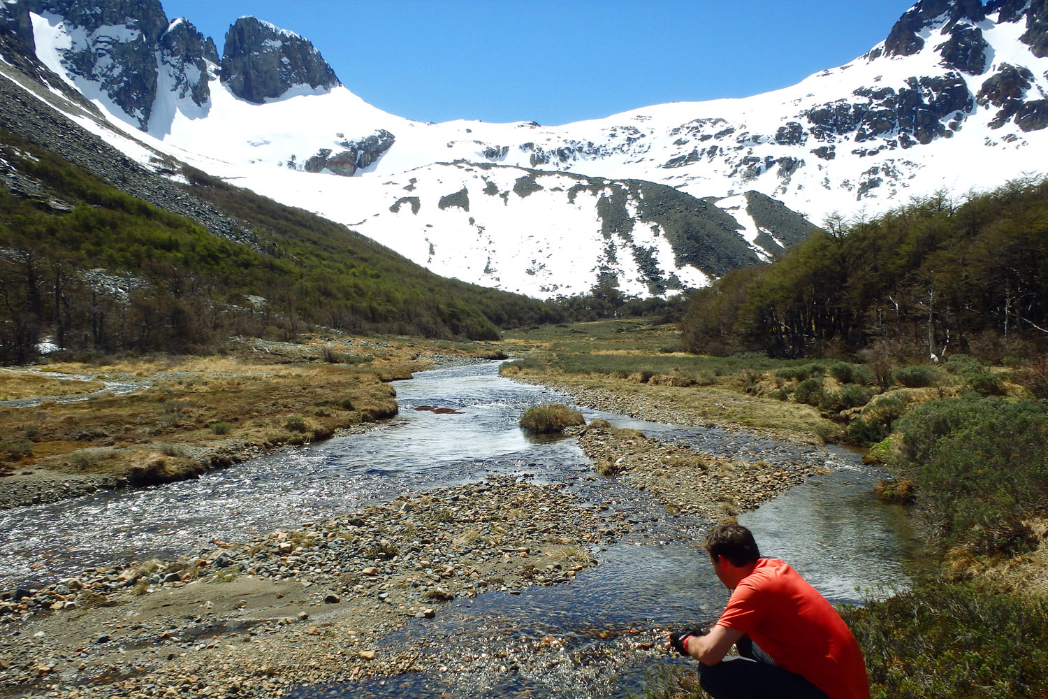
The Las Horquetas trail head is located along Route 7 (Southern Highway) south of Coyhaique approximately 67 kilometers towards the town of Cerro Castillo. At a sharp curve in the road, you’ll find a small parking area and after crossing the river, our ranger station. Here you can register and pay your park entrance fee. The trail follows an old logging road, weaving in and out of the forest with relatively no incline. Once reaching the official park boundary, continue another 2.5 kms until Camp Turbio. There are several small streams to cross and beautiful beech forests with Spanish moss.

TRAMO 2: CAMPAMENTO TURBIO - CAMPAMENTO BOSQUE VIEJO
9.8 kms. | DIFICULTY: HIGH
Duration: 5-7 hours approx.
Ascent: 570 meters.
Descent: 554 meters.
The second leg of the hike ascends to the Peñón Pass, climbing to 1,300 msnm, and back down in to the valley to Camp Bosque. Leaving Camp Turbio, you’ll begin hiking through the beautiful Turbio Valley until reaching the tree line and hiking through the saddle. The Penon Pass not only has snow in the winter, but can also be snow covered between the months of October and January. Hike through with extreme caution and beware of the loose rocks on descent. Camp Bosque is located next to the Bosque River and at the feet of the mountains.

TRAMO 3: CAMPAMENTO BOSQUE VIEJO - CAMPAMENTO LA TETERA
2.5 kms. | DIFICULTY: MEDIUM
LA TETERA CAMP CLOSED FOR RECOVERY
Duration: 2 hours approx.
Ascent: 300 meters.
Leaving El Bosque campsite, you must cross the El Bosque stream, which is a fairly fast river. The trail climbs steeply to Cerro Castillo, where you begin to appreciate the Cerro Castillo massif along with its glaciers, passing through a wonderful waterfall.
This section is short but has a steep elevation.

TRAMO 4: CAMPAMENTO LA TETERA -CAMPAMENTO PORTEADORES
5.7 kms. | DIFICULTY: HIGHT
CAMPAMENTO LA TETERA CLOSED FOR RECOVERY
Duration: 6-7 hours approx.
Ascent: 440 meters.
Descent: 374 meters.
This leg of the trail brings you to the famous glacial lake of Cerro Castillo, where you’ll be able to see its glaciers and peaks in their entirety. You can also make the decision to continue the hike through to Camp Porteadores, or take the private trail and concession of Jorge Aguilar directly to the town of Cerro Castillo.
The route passes the tree line and ascends towards the overlook of Cerro Castillo along a rocky trail approximately 150 meters pass the head of the Bosque River, towards the ridgeline. Once reaching the overlook, continue hiking along the ridge over “Morro Negro” until descending to Camp Porteadores, a steep 500 meter descent.
CAUTION:
-
This section of the trail is very exposed to high winds, steep cliffs and loose rock scree. It’s a critical spot on the trail and visitors should try to cross the pass in the morning. If the weather deteriorates while hiking to the overlook, it’s best to hike down directly to Villa Cerro Castillo. Visitors can experience white outs and fog surrounding the peaks making it difficult to follow the trail over the pass.
-
The drainage from the Castillo lake is one of the last places visitors will be able to find water while hiking from the lake over to Camp Porteadores. Be sure to fill up there before continuing your ascent.

TRAMO 5: CAMPAMENTO PORTEADORES - CAMPAMENTO NEOZELANDÉS
3.3 kms. | DIFICULTy MEDIUM
Duration: 2 hours approx.
Ascent: 285 meters.
This part of the trail gradually climbs to the final valley, Estero Parada, as it meanders through mystical old growth forests before arriving at Camp Neozelandes. A natural glacial cirque, visitors will be amazed at the beauty of the different peaks and glaciers, specifically the Northwestern face of Cerro Castillo, Cerro Palo, and Cerro Chocolate. The trail to Lake Duff is accessed from this valley as well, which is not within our trail concession.
One of the shorter sections on the route, visitors can hike for the day to the Estero Parada valley and Camp Neozelandes and return to Camp Porteadores to sleep without moving camp.
TRAMO 6: CAMPAMENTO NEOZELANDÉS - CASETA ESTERO PARADA
7.7 kms. | DIFICULTAD MEDIA
Duración: 4.5 horas aprox.
Descenso: 865 mts.
The final section of the trail descends rapidly to the trail head and road leading to the town of Cerro Castillo. It’s full of life with Andean beech forests, both old and second growth, wild strawberries, and orchids. After arriving at the road, there are approximately 6 kilometers before arriving back at town.
